


Sentier de la Hague 2022

joebartwix
User
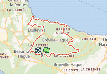

Length
18 km

Max alt
157 m

Uphill gradient
360 m
Km-Effort
23 km

Min alt
3 m

Downhill gradient
359 m
Boucle
Yes
Creation date :
2022-05-22 07:39:28.631
Updated on :
2022-05-22 10:48:53.25
3h08
Difficulty : Very difficult

FREE GPS app for hiking
 SityTrail
IGN / Geographical institutes
SityTrail Plus
The world is yours!
About
Trail Walking of 18 km to be discovered at Normandy, Manche, La Hague. This trail is proposed by joebartwix.
Positioning
Country:
France
Region :
Normandy
Department/Province :
Manche
Municipality :
La Hague
Location:
Unknown
Start:(Dec)
Start:(UTM)
585475 ; 5501749 (30U) N.
Comments